Updated Aug. 26, 2020 – 1830
- Overview
- Update from the National Hurricane Center
- Airport & Equipment Information
- Route Information
- Operational Resources
- NBAA’s HERO Database
Overview
Hurricane Laura has rapidly strengthened into a major hurricane (Category 4) and could potentially bring a catastrophic storm surge up to 20 feet in some places, extreme winds and flash flooding (15 inches of rain in some areas) to the northwest Gulf coast by this evening. Laura is located about 200 miles SSE of Port Auther, TX and Lake Charles, LA. Laura is moving northwest at 16 mph with max winds at 140 mph.
Landfall will be in the overnight hours (around 06z) likely between Houston, TX and Lake Charles, LA. Hurricane force winds extend significantly ahead and will be ashore much sooner. The Houston area is currently forecasting 25kts gusts. Both BPT and LCH are forecasting significant wind increases during the 06z hour with gusting from 90 to 100mph. Tornadoes and severe thunderstorms are probable this evening, through the overnight and into Thursday across Louisiana, far southeast Texas, Arkansas and southwestern Mississippi.
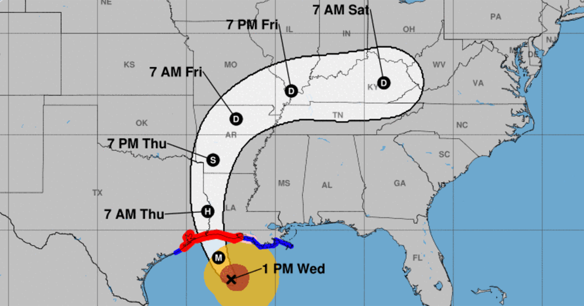
Laura – Update from the National Hurricane Center
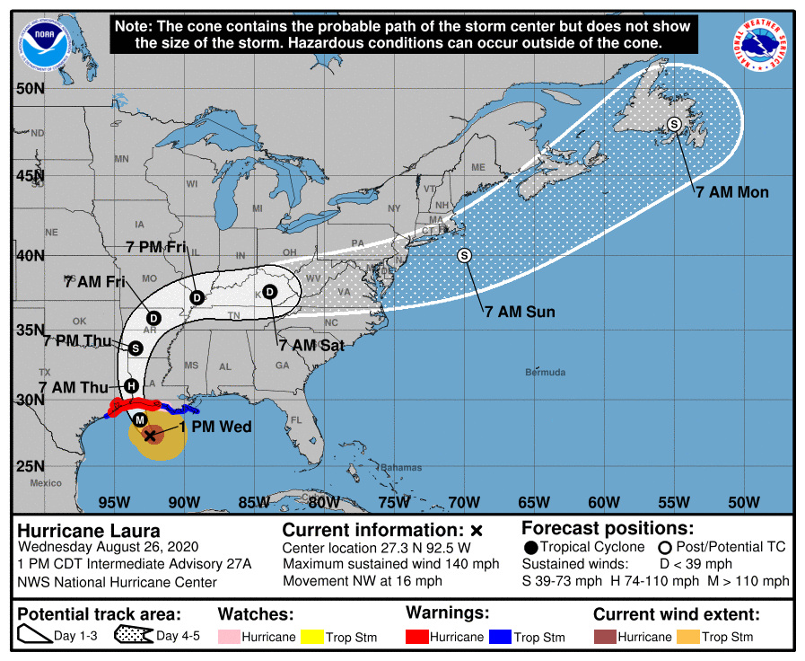
According to the National Hurricane Center’s Advisory #27A issued at 1700z:
At 100 PM CDT (1800 UTC), the eye of Hurricane Laura was located near latitude 27.3 North, longitude 92.5 West. Laura is moving toward the northwest near 16 mph (26 km/h). A gradual turn toward the north-northwest and north is expected later today and tonight. On the forecast track, Laura will approach the Upper Texas and southwest Louisiana coasts this evening and move inland within that area tonight. The center of Laura is forecast to move over northwestern Louisiana tomorrow, across Arkansas Thursday night, and over the mid-Mississippi Valley on Friday.
Reports from an Air Force Reserve Hurricane Hunter aircraft indicate that maximum sustained winds have increased to near 140 mph (220 km/h) with higher gusts. Laura is an extremely dangerous category 4 hurricane on the Saffir-Simpson Hurricane Wind Scale. Some additional strengthening is possible this afternoon, and Laura is forecast to remain a category 4 hurricane through landfall tonight. Rapid weakening is expected after Laura makes over land.
Hurricane-force winds extend outward up to 70 miles (110 km) from the center and tropical-storm-force winds extend outward up to 175 miles (280 km). Tropical-storm-force winds have reached the coast of Louisiana and an observing site at Eugene Island recently measured sustained winds of 39 mph (63 km/h) and a gust to 64 mph (104 km/h).
The latest minimum central pressure estimated from reconnaissance aircraft data is 952 mb (28.11 inches).
Airport & Equipment Information
Jack Brooks Regional Airport (BPT) closed
Lake Charles Regional Airport (LCH) ATC Zero
Gulf of Mexico
- MULTIPLE ADS-B GBT SERVICE ISSUES.
Lousiana
- ATLANTIS, LA (QA8) RCAG. FACILITY SUPPORTS HOUSTON (ZHU).
- BLIND FAITH, LA (QIG) RCAG. FACILITY SUPPORTS HOUSTON (ZHU).
- BOXER, LA (QBW) RCAG. FACILITY SUPPORTS HOUSTON (ZHU).
- LAKE CHARLES, LA (LCH) ASR/MODES PROTECTIVE SHUTDOWN.
- VIRGO, LA (QVO) RCAG. FACILITY SUPPORTS HOUSTON (ZHU).
Texas
- BEAUMONT, TX (BPT) ASR/MODES PROTECTIVE SHUTDOWN.
Route Information
There are no formal routes being proposed for the immediate planning as Laura approaches, as traffic numbers have dwindled considerably to the region. As the storm comes ashore, enroute traffic will likely encounter deviations around weather and a potential TransCon required route tomorrow is possible.
Gulf Route Closures
- L207, L208, L214
- A766, A770
- M575, M345
Operational Resources
- National Hurricane Center
- FAA OIS page
- CADENA OIS page
- FAA Advisory Database
- FAA Current Reroutes
- FAA NOTAM Search
NBAA’s HERO Database
The NBAA Humanitarian Emergency Response Operator (HERO) Database is a list of people in the business aviation community who are part of disaster-response mobilization efforts. In the aftermath of major crises, basic information from the database is provided to organizations coordinating relief efforts. Learn more and register.